This is the first project using stable isotope analysis to combine animal husbandry and crop cultivation for reconstructing farming in the southern Levant (present-day Lebanon, Palestine, Jordan, and Israel) during the Bronze and Iron Ages (3,600 – 332 BCE). Until now, research focussed on what agricultural products were consumed and exported but not how these were produced. My project advances the theoretical framework of urbanisation by exploring regional pathways and their relationship to the environment. It contributes to global discussions on the rise of permanent inequality in societies by investigating how farming systems affect wealth inequality, whether this is a global phenomenon, and to what extent socio-political factors influence this.
This project is a British Academy Postdoctoral Fellowship funded by the British Academy. It starts in October 2023 and will wrap up in September 2026. Follow updates in my blog!
Historical Background
During the Bronze and Iron Ages in the southern Levant the first complex urban societies were emerging. However, this region was often influenced by its powerful neighbours. Most known to the public, is Ancient Egypt. They were trading partners with the southern Levant during the Early and Middle Bronze Age. However, things took a turn in the Late Bronze Age when Egypt conquered the region and turned it into a vassal state. In the Iron Age I, the southern Levant enjoyed a period of independence from outside control. But that did not last long. In the Iron Age II, the Assyrian Empire came along and took charge, turning it into a vassal state once again and imposing taxes.
Researchers assumed the way farming and cities developed in the southern Levant was similar to these other big empires. There, urban centers started with family alliances, leaders emerged, and they organized things like farming, construction, and military efforts. Temples played an important role in legitimizing their authority. As cities grew, they relied on the surrounding countryside for food. Recent studies, though, suggest something different: the southern Levant had its own unique path. The southern Levant was made up of many independent political and territorial groups, each with different economic strategies and settlement patterns. These settlements did not have a single cultural identity, and they did not have central administrative institutions like the big empires did. This makes the southern Levant stand out from its neighbours. It seems like it had its own way of becoming urban, and it adapted to different environmental conditions with distinct economic and social factors.
Did the presence and collapse of empires in the southern Levant affect farming there? And how did taxation imposed by external powers impact local farming and inequality? To find out, I am conducting an agroecological study of the southern Levant to see how past empires influenced farming and inequality in their vassal states.
Farming in the past
So, how is farming linked to (wealth) inequality? Different methods of farming are identified by investigating the limits of their production (labour versus land). Intensive, or labour-limited, farming systems feature labour-intensive cultivation practices (manuring, middening) which are time-consuming, allowing less land to be worked. The yields obtained this way typically only suffice for survival subsistence and little to no surplus can be produced. In extensive, or land-limited, farming systems, yields per area are low when compared to intensive farming systems, but the absolute scale (the amount of land worked) of this low-input cultivation is much greater, enabled through the cultivation of as much land as possible, e.g., by using oxen teams, irrigation, and terracing. Such practices allow farmers to obtain higher total yields and create a substantial surplus, used for market and supporting non-producers. Extensive farming practices promote land shortage, and the available land is unevenly distributed in society.
This project reconstructs the nature and intensity of farming systems in the southern Levant—particularly focusing on crop cultivation through examining levels of manuring and irrigation and animal husbandry through examining foddering—using stable carbon and nitrogen isotope analysis of archaeological crop and animal remains. In other regions, throughout time, farming practices have been shown to contribute to wealth inequality through discrepancies in production caused by land ownership (and labour animals) and capacity to generate a surplus to support non-producers.
Goals
This project has five goals which it will achieve by combining (bio)archaeology, economics, and stable isotope analysis.
- Reconstructing crop cultivation practices.
I will do stable isotope analysis on charred archaeological seeds and pulses to reconstruct water availability, potential irrigation, and manuring. - Reconstructing animal husbandry practices.
I will do stable isotope analysis on bone collagen of archaeological animal bones to reconstruct foddering (i.e., C3 vs C4 plant intake), and consumption of manured crops. - Reconstructing wealth (in)equality.
I will calculate Gini coefficients (a measure of economics) using the size of individual households from the sites for which I used stable isotope data. - Synthesising farming and wealth (in)equality.
I will explore the relationship between farming and wealth (in)equality and research to what extent past empires affected farming systems in their vassal states. - Integration with present-day farming sustainability practices.
By working together with non-profits and NGO’s, I will use the knowledge of past farming systems, specifically their robustness to climatic and societal changes, to contribute to present-day integrative farming developments and explore new methods for sustainability.
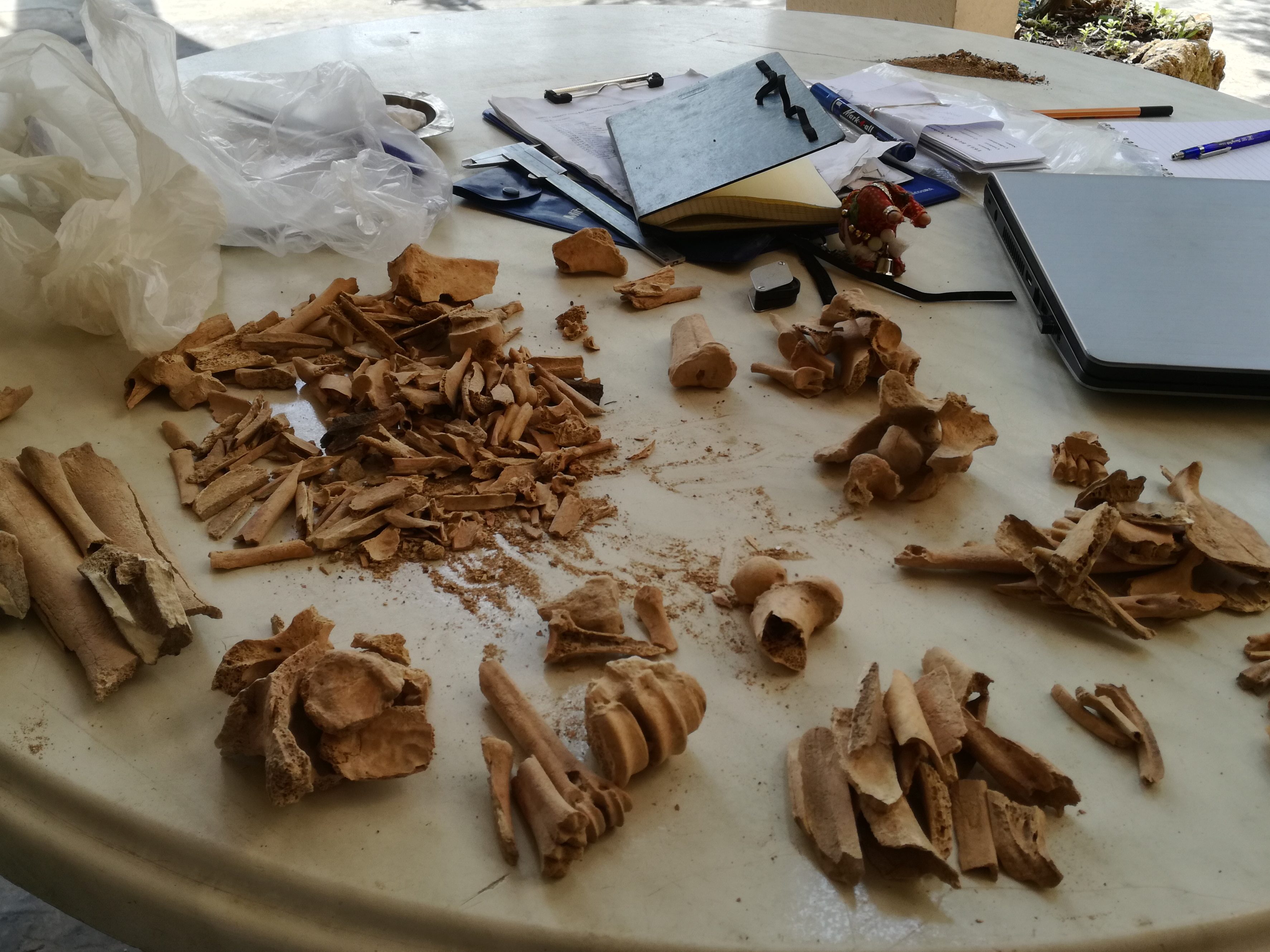
Methods
This project will use stable carbon and nitrogen analysis of animal bones and charred plants too reconstruct farming. It also uses Gini coefficients, a measure of economics, to estimate wealth (in)equality.
Past crop cultivation is reconstructed by determining δ 13C and δ 15N values of charred archaeological seeds from crops (e.g., wheat, barley) through stable isotope analysis. When fields are manured, higher levels of manuring result in higher δ15N values of crops. Charred archaeological crop seeds retain their original δ15N values meaning stable nitrogen isotope analysis is a reliable method to reconstruct manuring practices of the past. Water availability plays a key role in the success of crop cultivation. Since photosynthesis is related to water status in plants, and there is a negative relationship between δ13C values of plants and moisture conditions, stable carbon isotope analysis gives insight into the water stress, irrigation practices, and climatic conditions ancient crops faced. By interpreting the δ13C and δ15N values of crops in their environmental and social context, past farming systems are situated on a spectrum of extensive to intensive systems, depending on the amount of agricultural labour per area of land.
Past animal husbandry is reconstructed by determining δ13C and δ15N values of bone collagen of livestock (e.g., cattle, sheep) through stable isotope analysis. Bone collagen reflects the isotopic composition of the diet during the final years of an animal’s life. δ13C values give insight into the relative contributions of C3 (e.g., wheats, oats) and C4 (e.g., millet) plants. Thus, stable carbon isotope analysis provides information on the components of an animal’s diet. When animals feed on manured crops, this will result in higher δ15N values in the animal than when fed from nonmanured crops, since the effects of manuring are transmitted up the food chain. Thus, stable nitrogen isotope analysis reflects the consumption of manured crops and their by-products by animals.
Ownership of commodities such as land, housing, and livestock, gives advantages to individuals and provides an indication of their wealth. The size of a household represents an indicator of its ability to acquire space within a settlement and gather labour and resources. Larger houses represent increased access and control over commodities, leading to more wealth. The Gini coefficient is a measure of wealth inequality measuring the unevenness in the distribution of commodities. I will use the size of households within a settlement as an indicator of inequality within a settlement. Since the Gini coefficient represents an absolute measure, it can be compared for different regions and periods
